Distance measurement – large scale
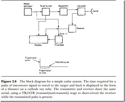
The predominant method of measuring distance to a target point on a large scale is based on wave reflection of the type used in radar or sonar. The principle is that a pulse of a few waves is sent out from a transmitter, reflected back from some distant object and detected by a receiver when it returns. Since the speed of the waves is known, the distance of the reflector can be calculated from the time that elapses between sending and receiving. This time can be very short, of the order of microseconds or less, so that the duration of the wave pulse must also be very short, a small fraction of the time that is to be measured. Both radar and sonar rely heavily on electronic methods for generating the waveforms and measuring the times, and although we generally associate radar with comparatively long distances, we should remember that radar intruder alarms are available whose range is measured in metres rather than in kilometres. Figure 2.6 shows a block diagram of a radar system for distance measurement, such as would form the basis of an aircraft altimeter. A sonar system for water depth would take the same general form, but with different transducers (see Chapter 5). The important difference is in wave speeds; 3 x 10⁸ mfs for radio waves in air, but only 1.5 x 10³ mfs for sound waves in sea-water.
Vhere radar or sonar is used to provide target movement indications, the time measurements will be used to provide a display on a cathode ray tube, but for altimeters or depth indications, the time can be digitally measured and the figure for distance displayed. Before the use of radar alti-
meters, the only method available was barometric, measuring the air pressure by an aneroid capsule and using the approximate figure of 3800 Pa change of pressure per kilometre of altitude. The air pressure, however, alters with other factors such as humidity, wind-speed and tem- perature, so that pressure altimeters are notoriously unreliable. Even if such an altimeter were to give a precise reading, the height that it measures will either be height above sea-level or the height relative to the altitude of the place in which the altimeter was set, rather than true height. It is, in fact, remarkable that air travel ever became a reality with such a crude method of height measurement.
Position measurement on a smaller scale (e.g. factory floor scale) can make use of simpler methods, particularly if the movement is confined in some way, such as by rails or by the popular method of making a robot trolley follow buried wires or painted lines. For confined motions on rails or over wires, the distance from a starting point may be the only measurement that is needed, but it is more likely that the movement is two- dimensional. Over small areas of a few square metres, an artificially generated magnetic field can be used along with magnetic sensors of the types already described. Radio beacon methods, using very low power transmitters, are also useful, and ultrasonic beacons can be used; although problems arise if there are strong reflections from hard surfaces. For a full discussion of the methods as distinct from the sensors, the reader should consult a text on robotics.
